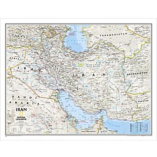
This new map of Iran is made with the classic National Geographic reference styling. It features thousands of place names, accurate political boundaries, archeological sites, and major infrastructure networks such as roads, canals, ferry routes, and railroads. Iran’s diverse terrain is detailed through accurate shaded relief, coastal bathymetry, and symbolism for water features and other landforms. Elevations of major peaks are expressed in both feet and meters; depth soundings are expressed in fathoms.
•Scale: 1:3,696,000 (1 Centimeter = 37 Kilometers; 1 inch = 58 Miles)