Smarter and safer with the GPSMAP 496 on board
In the air, on the road, at sea...
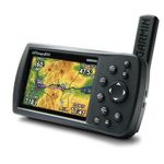
The GPSMAP 496, a full-color, portable aviation device expands on the GPSMAP 396’s features by incorporating Garmin’s SafeTaxi™ airport diagrams, Garmin’s Smart Airspace™, AOPA’s Airport Directory data, enhanced high-resolution terrain database, aviation database with private airports and heliports, accelerated GPS update rate, and pre-loaded automotive maps of North America or Europe.