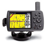
Go straight from the box to your boat to your vehicle with the portable GPSMAP 378. Along with its counterpart, the GPSMAP 478, this combination color chartplotter and street navigator comes preloaded with detailed marine maps and detailed street maps, so you can find your way anywhere. The 378 accepts optional MapSource data cards, so you can add new maps without connecting to your computer. Optional BlueChart g2 data cards let you view real, detailed aerial photos of harbors, marinas and other important marine landmarks and places, right on your chartplotter. Ready for action right out of the box, the GPSMAP 378 comes preloaded with detailed U.S. Inland Lakes data, which boasts 10-meter resolution for more than 3200 lakes, many with depth contours. The maps also show streams and rivers, tide stations and predictions, a wrecks and obstructions database and U.S. Coast Guard aids to navigation.